Recently I visited some collaborators in Minamisoma, Fukushima, and after our work was done they took me to the exclusion zone around the nuclear plant. We didn’t enter the innermost zone, but traveled right up to edge of it. Similar to Chernobyl, the area is slowly being reclaimed by the wilds, and its level of radiation contamination means this area hasn’t been cleaned up yet, so it still carries a lot of evidence of the destructive power of the tsunami that damaged the plant.
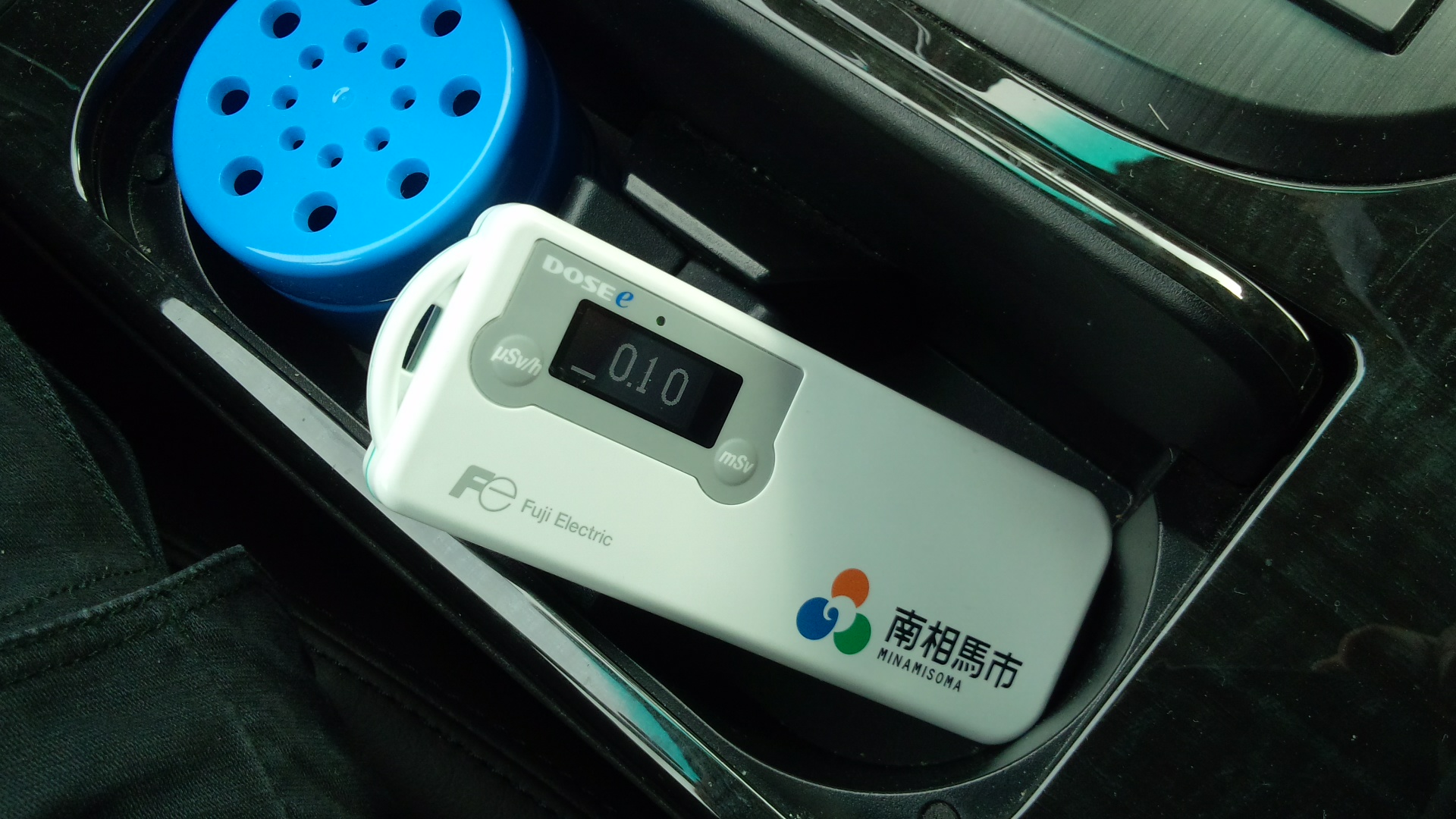
For this drive we first headed in the direction of Namie, then turned off the road to head towards the beach and the tsunami zone. We took a radiation counter with us (shown above) that measures external exposure in micro-Sieverts per hour estimated from 30 second averages. This means you can tell what your exposure would be if you stayed in the particular spot for an hour. Wikipedia tells me that normal background radiation levels are about 0.4 milli-Sieverts per year, which would be about 0.05 micro-Sieverts per hour, so the background level in the car is not so bad.
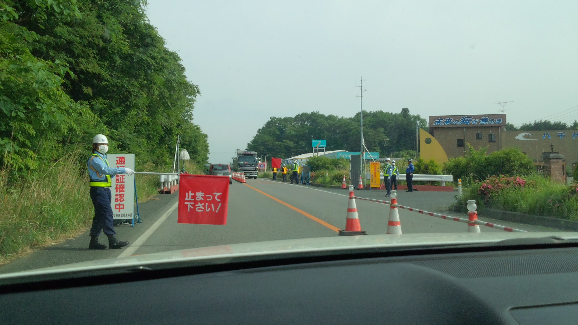
We were refused permission to continue to Namie, because that area is directly under the original radiation plume and the only people allowed in or out are those with a reason to be there. I think it’s safe to say that no car with a foreigner in it is going to Namie for a valid reason, since it’s a tiny town (now empty, I think) that probably has never had a resident foreigner. You need a special permission to pass through, and we didn’t have it, so we turned back and headed to the sea. Note the sign on the roof of the house in the distance: it says “Thinking about the seas of the future.” I find this quite ironic.
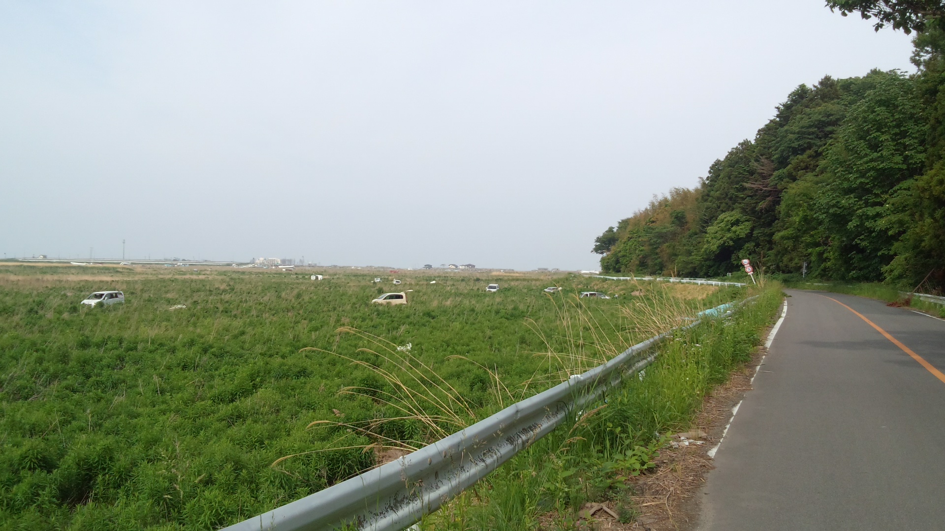
Turning off the road, we traveled down this small side road towards the sea. In this picture it’s about 2km distant, just audible when one steps out of the car. The land to the side of the road used to be a mixture of rice paddies and houses, but now it’s all overgrown. In the distance along the road you can see the barriers being reclaimed by the forest, and the trees growing over the road. The cars in the field are in the position where the tsunami left them two years ago. In case anyone doubts what the nuclear plant was up against, let’s just think on this for a moment: the tsunami washed this far inland over a sea wall and a mixed community of houses and farmland, carrying a brace of cars with it. It must have come to its end about here, because the road is relatively intact and the cars upright and uncrushed.

The boat in the picture above is the Number One Lucky Omen (dai ichi kichijo maru). I don’t know if it was dragged here by a clean up team or the tsunami, but the area around has other, larger boats scattered about. It’s some kind of fishing boat, I think. In the background on the left are the remains of a few cars. Now we’re perhaps a kilometre from the sea, and it should be obvious that the tsunami at this point is not being so merciful as to leave cars upright and uncrushed. In the background is a primary school, almost completely intact. It is a quite modern building, obviously designed to withstand real damage. I was told that all the children in that school survived. Schools have catchment areas, but this school is standing on its own in a huge field. Its catchment area was washed away.

This picture shows a kind of tetrapod, cast aside on the landward side of the sea wall. The sea wall is just visible in the background as the horizon. Tetrapods are huge chunks of geometric concrete that are piled up on beaches in Japan as wave breaks. They interlock with each other and form a kind of barrier at the edge of the sand. They are huge and made entirely of concrete. The tsunami picked up these tetrapods and carried them over the sea wall, dropping them perhaps a hundred metres inland of the wall as it raged forward. The area around these tetrapods was populated – just behind me as I took this picture stood the remains of a house, and a flattened area that once held a shrine. That means these tetrapods were smashing through houses as they came inland. If you look at the sea wall in the background you can see things sticking out of it, pointing upwards at the sky. These are the innards of the wall. The tsunami didn’t just rush over this wall, it tore it apart as it came.
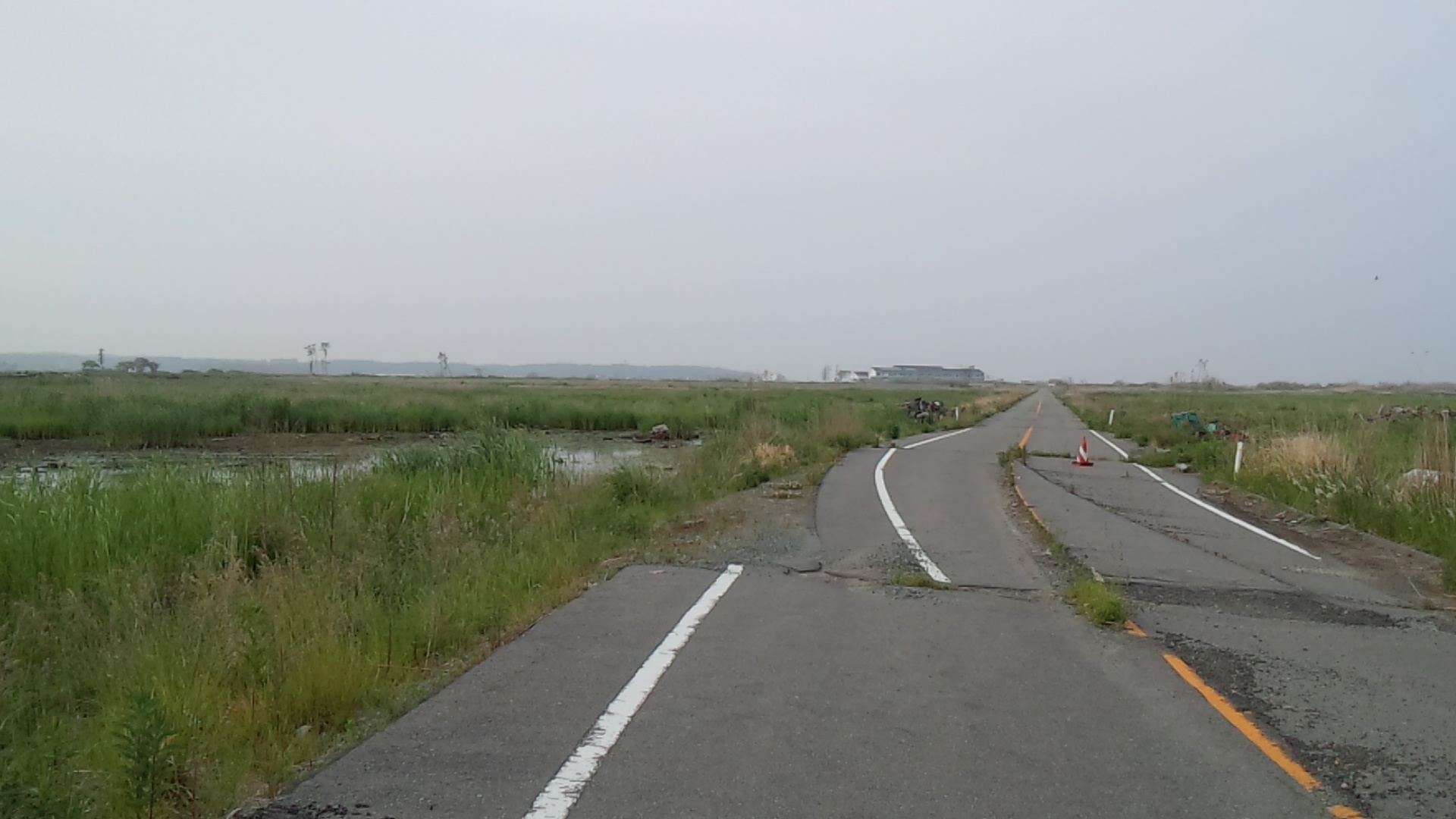
From that point we headed south towards the exclusion zone. This shot is looking back the way I came (you can see the same primary school looming on the horizon just to the left of the road). The road is, obviously, in a bad state: those traveling with me thought this was likely the effect of the original earthquake rather than the tsunami. I don’t like to think about how terrifying that earthquake was, because it was pretty scary in Tokyo and we didn’t see anything twisted or broken. The nuclear powerplant had to be resistant against this earthquake, and then the tsunami that followed, even though it was built 40 years ago. It’s quite a miracle really that it didn’t collapse completely. Note the pond to the left of the road: this is another example of nature reclaiming the area, and was rich with the sound of frogs and insects. Soon after I took this photo an enormous crane took off from the reeds and flew to the distant forest.
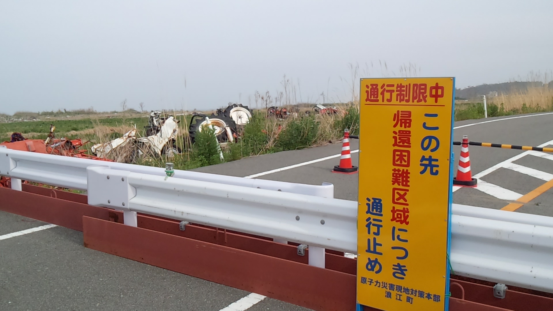
Turning around from that picture we find ourselves facing the barrier to the inner exclusion zone. This is the 10km zone: you can see the roof of the powerplant in the distance over the trees. No one is supposed to enter this region, because a little further south and west of here you will enter the area most heavily affected by the plume. We didn’t cross the barrier. Note the ruined tractor on the verge of the road.

This is a picture of the landscape immediately to the right of the barrier. There is a swampy area full of frogs, insects and small birds, and then beyond that a small hill that would once have been a satoyama, surrounded by local homes and rice paddies and probably with a small shrine in the middle. Satoyama are a unique form of ecosphere intimately connected with Japanese farming techniques, but the satoyama around here have gone wild. This area was thick with birdlife, so standing here I could hear a cacophony of bird song such as I have never heard in rural Japan before. Usually birdsong in Japan is limited to a few common croaking and sqwarking birds, but here there was a symphony of singers. High, warbling birdsong like something from Europe mingled with strange, throaty cries and a kind of laughing whoop that I have never heard before. The area was alive with animal life. In just two years, this whole area has become a huge wildlife sanctuary, and birds that would not normally come near human settlement have proliferated. I think usually you would only hear these birds in the deepest forests, or perhaps in some rare farming communities; but here they are easily accessible in amongst the new growth of the devastated area. I think the people of Minamisoma should leave this area as it is; as a kind of combined wildlife park and memorial, so people can visit to enjoy the sight of Japan how it once would have been, before it was cultivated; and simultaneously appreciate the fury of the ocean, and the damage that was done because the post-war builders ignored the stories handed down to them from previous generations.
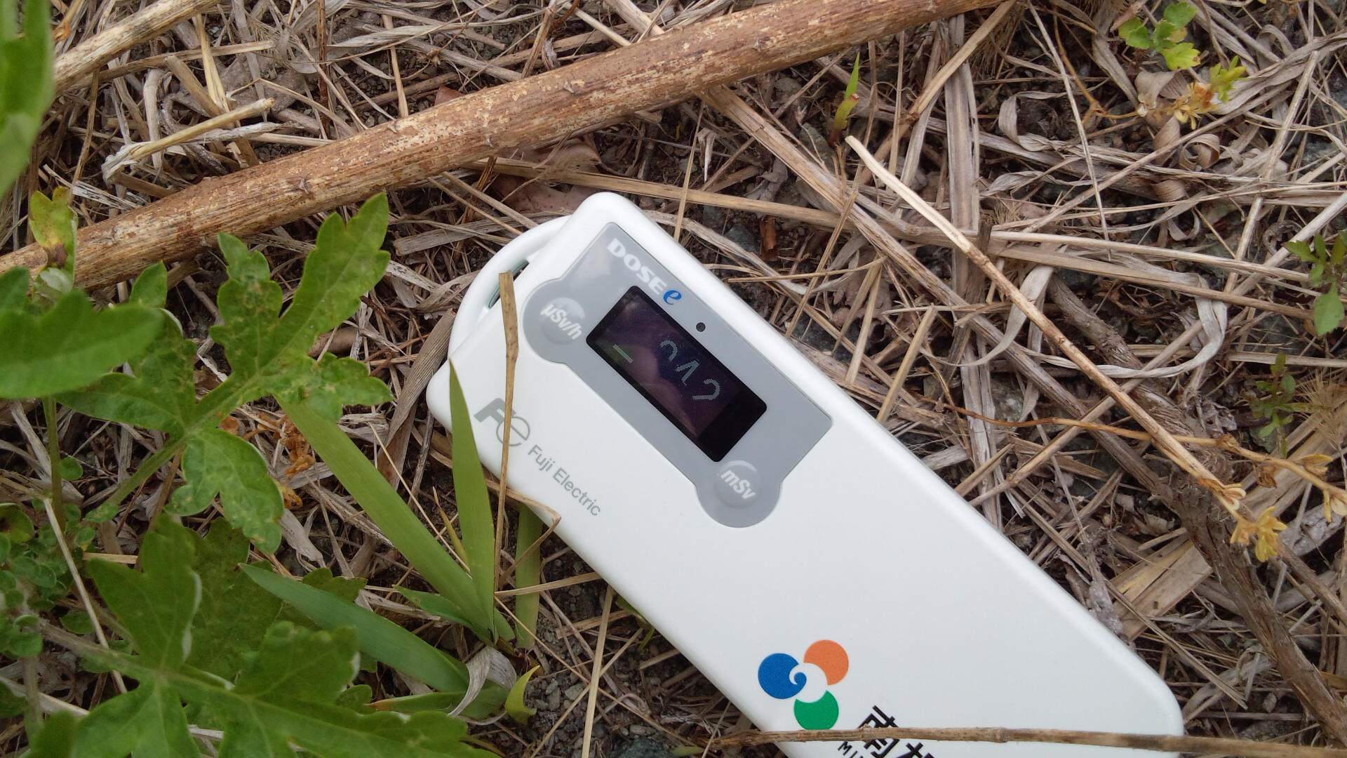
Finally, here is a photo of our Geiger counter, taken at the barrier. It was hard to get a clear shot due to the frequency of the screen, but it now reads 0.42. This is approximately eight times the background level of Japan (maybe five or six times if you take into account cosmic rays and backscatter from the ground). It’s probably not actually a serious enough level of radiation to preclude redeveloping this area and allowing people to live here again, but I think it would be better if they didn’t. Japan doesn’t lack for wild places (about 70% of Japan’s surface area is forest) but it would be a fitting memorial to the triple disaster and an interesting exercise in ecosystem development to let this place return to nature. I think it’s also very apt for a pagan society to make a memorial out of the wilderness. So, here’s to the lives lost in this stretch of coast, and hopefully they can be honoured through some kind of wildlife sanctuary – a terrestrial mirror of the wild ocean that originally took those lives, and cast this place back to nature.

Leave a comment